Hiking Courses
How to visit
Run on the national road no. 43 from Seoul to Uijeongbu through Chukseongryeong, Pocheon, Manse Bridge, Yangnum and Woncheon.
Departure from DongSeoul Bus Terminal (02-446-8000) Bus to Shin Cheorwon (via Pocheon, Shinbuk, and Woncheon) / 06:00~21:20 (interval 10~20 min.)
/ 2 hours and 20 min. / 7,800 won Night Bus 22:00, 22:45, 23:30 / 2 hours and 20 min / 8,600 won
Departure from Suyuri Intercity Bus Terminal (02-995-9188) Shin Cheorwon (Wasu-ri), get off the bus at the Shin Cheorwon Station / 5:50 ~20:35 (interval 30~40 min)
/ 2 hours / 6,600 won From Shin Cheorwon Intercity Bus Terminal (033-452-2551) to DongSeoul Bus Terminal: 05:00~23:30 (interval 10~20 min) From Shin Cheorwon
Intercity Bus Terminal (033-452-2551) to Suyuri Intercity Bus Terminal: 06:05~20:40 (interval 30~40 min) Subway (Line No. 1) - Dongducheon Station (Commuter Train) -
Sintan-ri Station - Bus to Shin Cheorwon or Ipyeong-ri
-
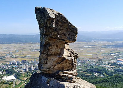
Mt. Ceumhaksan
as a crane sits down, the scenery is profoundly beautiful.
Mt. Geumhaksan boasts grand spectacles, looking down over the great Cheorwon Plain. Mt. Geumhaksan
is the representative celebrated mountain of Cheorwon, with a height of 947.3m above sea level.
The mountain is called Geumhaksan because it looks like the figure of a crane coming down. The mountain
has steep and magnificent geographical features, so it is appropriate for climbing.
There are historic relics such as an engraved stone Buddha (Maaebulsang), and the remains of Budo stones
known to have been built in the mountain in the early Goryeo Dynasty. -
Mt. Myeongseongsan
as if listening to sorrowful crying
Mt. Myeongseongsan, known as the Crying Mountain, is a celebrated mountain with a height of 923m above
sea level, overlooking the southeast part of the Cheorwon plain.
There's an anecdote that tells why the mountain is called the Crying Mountain. Once upon a time, King
Gunye set up the capital in Cheorwon Pungcheonwon and ruled the nation named Taebong. When he lost
the support of the people and his throne to his subordinates, he escaped to Mt. Myeongseongsan to fight
against the army of Wang Guen. During the fight, as they became exhausted, he inevitably broke up his
army in the mountain. There, admirer and devotees of Gungye became so sad and cried loudly. It is said that
people could hear the sound of sad mourning from time to time ever since then. Some relics, such as the
site of ancient castle where Gungye hid himself, still remain on the mountain. -
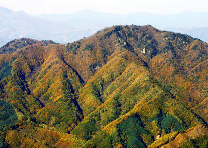
Mt. Bokgyesan
the northernmost mountain running on the land of south korea
In the north east part, there is the truce line and Mt. Daesong. Mt. Bokgyesan boasts awesome views and
dense forests. On the west ridge line from the peak, there is Maewoldae where Kim Si-Seub, one of
Saengyuksin (six loyal subjects) in the time of King Danjong and another either scholars lived in retirement.
The south gorge is famous for Maewoldae falls. Wongolgil, the escaping path for the head of the town, is
located in the thick forest and deep valleys; the daytime there is as dark as the nighttime. With 950 peaks,
including Chotdaebong, south from the top and rugged forest paths, the mountain provides pleasant
mountain climbing for tourists. -
Mt. Bokjusan
mounting like a silver lining
Mt. Bokjusan and Hoemokbong are located between Supiryeong of Mt. Daeseong and Haohyeon of Mt.
Gawngdeonk within the Hanbook Mountains. Since the control on entering mountain was recently lifted, the
mountain hasn't been polluted.
On the top of mountain, you can see the fields and mountains of North Korea. Also, the mountain has a good
view of Mt. Daeseongsan, Baekjeonsan, Hwahaksan, and Mt. Baekwunsan. Heomokbong has various
shapes of ridge lines, and the paths to the top are covered with pampas grass.
There are many rocks of unique shapes such as the Skirt Rock (Chima Bawi) and Cap Rock (Gamtu Bawi).